|
|
|
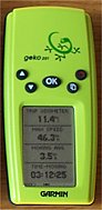 Intrigued
by Garmin's Geko 201 Personal Navigator®? It's smaller than an
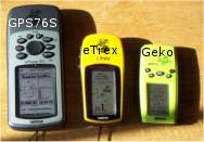
eTrex and dwarfed by its big brother, a GPSMAP 76S (below). Intrigued
by Garmin's Geko 201 Personal Navigator®? It's smaller than an
eTrex and dwarfed by its big brother, a GPSMAP 76S (below).
First, the Geko
is a serious GPS receiver. It features WAAS differential
correction; memory for 500 waypoints, twenty routes, a whopping
10,000 track points and ten saved tracks; and it connects to external
power or to your PC for data transfer with an optional cable.
It floats. The array of five buttons is easy to use. The screen
is small (about a third of the screen dimensions of the GPSMAP
76), but it's not hard to read. Menu choices allow configuration
of the data screens to your liking. The back is rubberized, and
so you can lay it on your dashboard and not have it slide around.
Using only two AAA batteries, the unit is light as well as small
enough to fit in a shirt pocket (but the limited power supply
may be an issue for some as explained below).
The Geko also
has four built-in GPS games, a novelty to emphasize that GPS can
be fun. Interestingly, the Geko games are similar to serious field
data collection methods that use GPS to follow pre-designed waypoint
grids.
The Geko doesn't
show base maps but is adept at recording points and lines. If
you want a GPS unit primarily for hiking or recording locations,
the absence of base maps isn't that significant. Fact is that
the base maps in many GPS units don't provide enough detail (unless
you can download more features from a CD) to be of much use at
a close-in scale. If you wish to see highway maps when you are
traveling, the Geko easily connects to a PDA or laptop computer
to display your location in inexpensive navigation programs or
projected on aerial photos. (Check out Vito
Smart Map, or Delorme XMap Handheld Pro, inexpensive Pocket
PC programs that turn the Geko into a sophisticated mapping receiver.)
 The
Geko utilizes a built-in "patch" antenna (a square plate
inside the unit, located under the lizard logo). It works best
in a horizontal orientation (the top edge of the unit pointed
to the horizon). That way the antenna can look up to the sky.
The Geko provides remarkable GPS satellite reception while held
naturally in your hand or laid on your car's dashboard. The Geko
is more comfortable to hold than the larger GPS 76 series (which
uses a quad-helix antenna that works best in a vertical position
with the unit's top edge pointed at the sky). The
Geko utilizes a built-in "patch" antenna (a square plate
inside the unit, located under the lizard logo). It works best
in a horizontal orientation (the top edge of the unit pointed
to the horizon). That way the antenna can look up to the sky.
The Geko provides remarkable GPS satellite reception while held
naturally in your hand or laid on your car's dashboard. The Geko
is more comfortable to hold than the larger GPS 76 series (which
uses a quad-helix antenna that works best in a vertical position
with the unit's top edge pointed at the sky).
|
|
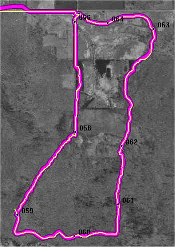
As an experiment,
I took both the GPSMAP 76 and the Geko 201 (one in my left hand,
the other in my right) on a hike through a forest. The tree leaves
weren't out yet (mid-March in Wisconsin), but the timber on the
test site is large and the terrain hilly. I wanted to see if the
Geko could hold a track in a wooded situation.
The tracks of
the two units appear to the right. The GPSMAP 76S track is
the wide purple line, while the Geko track is yellow. I started
out with WAAS turned on for both units; but since the differential
correction signal was lost as soon as I stepped into the woods,
I turned it off on the Geko to preserve battery power.
My surprise
back home when I downloaded the tracks into OziExplorer was how
similarly the two units performed. As shown on the right, the
tracks lay directly on top of each other. The Geko experienced
a small spike and break in the track near waypoint 059, but overall
had no problem holding a signal. I also walked through a dense
pine plantation. Although the signal strength dropped for both
units, neither had any problem maintaining a position in this
test. (Results, of course, could be less favorable under heavy
summer foliage, less attention to holding the unit properly or
other factors.)
On the highway,
the Geko actually recorded a better track than the GPSMAP 76S.
The reason was that both units were laying flat on the dash. The
Geko works better in that orientation (although the GPS 76 will
accept an external antenna if needed whereas a Geko cannot).
|
 |
|
Garmin claims
that two AAA alkaline batteries can last up to twelve hours (on
battery saver mode). For economy, however, I use NiMH rechargeable
batteries. I know that NiMH power cells don't last as long as
alkaline in GPS units, but the duration of my 600 mAh batteries
was far shorter than I expected ―
only 40 minutes set on standard mode in 32° F March weather.
At 60° F (~16° C) the Geko ran just two hours in standard mode.
It operated five and a half hours in battery saver mode with NiMH
batteries on the warm dashboard of my car. [Note: Manufactures
are constantly improving the mAh rating of their cells.
800 mAh AAA cells are now available, which should provide better
performance than I've listed here.]
|
|
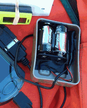
Since the Geko has a port for an
external power supply, an extra $29 cable will let you
plug it into a 12-volt cigarette lighter receptacle.
If you are away from your car for a long time, as on
a camping trip, you can use the Geko and power cable
with a
portable 12-volt battery pack (relatively inexpensive
at $30-$50).
For a much lighter external power source, online retailer
CycoActive
offers a
3-volt C-cell power kit for Geko 201 and eTrex GPS
units. It is practical to carry in a GPS case or on
a belt (or under your coat in the winter). The C-cell
pack is said to last three times longer than AA batteries
in an eTrex, and probably longer still in a Geko. You
can wire the cable so the battery powers the Geko and
the Geko sends GPS data to a PDA or PC. Check out the
wiring diagram for a Garmin
17N (p. 9) if you want to know how to attach GPS
wires from a CycoActive cable to a DB9 serial connector
and a battery. A circuit continuity probe ($2) will
help you tell which wire is which. (My battery box,
which doesn't come with the kit, is a traveler's plastic
soap box.)
|
|
|
|
I've
found that the watertight Geko serves as an external
GPS antenna for a navigation program that I use on my
iPAQ Pocket PC (Vito
Navigator). I've mounted the Geko on a 2.5' wooden
pole attached to a backpack. Using a
PC interface cable with 12-volt cigarette lighter adapter
or the C-cell setup described above, the Geko draws
power from a battery in the backpack and sends spatial
data to the iPAQ.
With
the Geko used as an external GPS antenna, I can use
the iPAQ for both forest inventory collection and real-time
mapping without juggling both a GPS unit and the iPAQ
data recorder. Another advantage to putting the Geko
on the pole is that I no longer need to worry about
keeping it oriented for good signal reception. The horizontal
mount on the pole is optimal and hands-free.
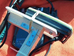
The
"Geko on a pole" approach (about $200 including
the GPS, cables and an external battery) works like
commercial GPS antenna/backpack setups that cost considerably
more. As shown in the photo, the construction is simple.
The Geko attaches to a plastic switch plate with a screw
(meant for a bicycle handlebar mount) and a rubber band.
Hot glue and another screw attach the plate to the pole.
Remove the screw and the rubber band to use the Geko
solo.
|
|
|
Top
/ ForestPal Home /
About
|
|
|
