| | | Unsure whether to purchase a GPS unit? See Discovering GPS, an article originally written for my friends at the Wisconsin Woodland Owners Association. It explains how GPS works and the differences between recreational grade units.
You might wonder, "Which is the right GPS unit for the job?" There are three general grades of GPS units: recreational grade, mapping or resource grade and survey grade. See the GPS Comparisons below to help choose the right tool for you. The table includes information about external GPS antennas and power supplies. | | GPS Comparisons | 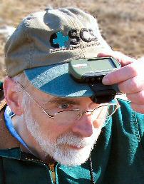 Click the image for a review of the Garmin Foretrex 201, mounted here on a hat for better GPS signal reception. | What are the limitations of a recreational grade GPS unit? Do you need more precision? The following table explains the basic differences between recreational grade and mapping grade GPS units. Note that both recreational grade GPS (depending upon the features of a particular unit) and mapping grade GPS are capable of real-time differential corrections. Differential GPS (DGPS) significantly improves accuracy, potentially reducing real-time error to less than 3 to 5 meters (<10 to 16 feet). The basic concept is that coordinates provided by the NAVSTAR GPS satellites are compared to readings at fixed locations. The differences between the NAVSTAR GPS readings and the known locations are used to calculate corrections that are applied to your GPS unit's location display. Professor Paul Bolstad and his associates at the University of Minnesota recently completed exhaustive comparisons of independent, WAAS, real-time, and post-processed GPS accuracies in northern forests. Curious how recreational GPS units measured up against resource grade units under forest canopies? Check here. | There are two types of real-time differential corrections available for recreational grade GPS: -
Corrections based on signals from geostationary Wide Area Augmentation System (WAAS) satellites (broadcasting corrections from about twenty-five US North American ground stations ...more to be added in 2003). Currently, only two WAAS relay satellites are generally visible from the US. The satellites are positioned over the equator. You need a good view of the southern sky to receive the signals. Since the reception angle is extreme, tree cover, hills or other obstructions including buildings or even your body can block WAAS signals. Eventually there could be as many as 19 WAAS relay satellites, making WAAS a dependable DGPS system, but deployment will be slow in coming. For a WAAS tutorial and additional links to coverage maps, see gpsinformation.net. (WAAS correction is not yet available outside North America but related European and Pacific systems are being developed.) -
Corrections based on signals from US Coast Guard (USCG) Differential Beacon Receiver Transmitters located throughout the USA. You must be in range of a USCG transmitter to use the system. Maps of USCG transmitter coverage are available at the above link. (Other differential base station systems are also employed elsewhere in the world.) Recreational grade units sold in the US typically use the WAAS system. Some recreational grade units can take advantage of USCG differential correction with an optional beacon receiver (e.g., the Garmin GBR 23 receiver). Mapping grade units might be designed to use WAAS, USCG or other reference station signals. They also save coordinate data in a format that can be used in post-processing correction programs, potentially resulting in sub-meter accuracy. Survey grade GPS is not included in the table. Survey grade units are used where accuracy is crucial (as in cadastral surveys, highway construction and other engineering projects). They are capable of providing horizontal accuracy to within a centimeter. The costs (up to $40,000), training requirements, time involved to establish readings and other factors make survey grade instruments impractical for general resource management applications. (Typically, a survey grade GPS is used to establish a known point. From there, total station laser instruments are used to lay out measurements for other positions in the vicinity of the known point.) | | GPS Comparisons | | Recreational Grade | Mapping/Resource Grade | | Primary Uses (Including Forestry Applications) | -
General navigation (including real-time moving maps), outdoor sports, hiking, geocaching, etc. See other GPS uses here. -
Collection of point data -
General forest reconnaissance using manual or digital inventory methods -
Relocating individual trees, a group of plants, a nest, etc. if the spot is flagged in some way so it can be seen when you get close -
Estimating acreage of forest stands/areas, although potential errors for small areas or areas with complex boundaries may be unacceptable. See the European Commission "Note on the use of stand-alone GPS for parcel measurement" or "Estimate of Area Calculation Error Using Handheld GPS" for discussions on the topic. Also, see "CAN A $300 GPS RECEIVER BE USED FOR YIELD MAPPING?" from the Missouri Precision Agriculture Center. (Their answer is yes. The average relative accuracy between a DGPS receiver and a low cost Garmin eTrex GPS receiver was only 7.9 feet (2.4 meters) when the eTrex was mounted outside a grain combine where it could get a clear signal.) | -
Resource mapping and navigation -
Collection of lines/roads and areas/stands in addition to point data. Associate GIS data collected on-site to the map objects. -
Forest reconnaissance using digital data recorders -
Measurement of areas to a higher level of precision (when used with differential correction) than possible with recreational grade units -
Relocating individual trees, a group of plants, a nest or other local features that are not otherwise flagged Note: You may need to plan GPS data collection to coincide with optimal NAVSTAR GPS, GLONASS (Russian GPS) or other satellite availability over your work area. Trimble offers free GPS planning software that determines the visibility of GPS satellites. (See the Trimble Planning Quick Start Guide from the USFS.)  | | Horizontal Data Accuracy (Based on Manufactures' Literature) | -
Typically <15 meters (49 feet) with no differential correction. Error greater under conditions such as dense tree foliage, steep terrain or poor satellite orientation. -
3 to 5 m (or 10' to 16') with WAAS real-time correction. Recreational GPS units have no post processing correction capability. | -
Typically <15 meters (49 feet) with no differential correction. Error greater under conditions such as dense tree foliage, steep terrain or poor satellite orientation. -
1 to 5 m accuracy in real-time or <50 cm accuracy with post-processing correction using base station differential corrections | | Vertical Data Accuracy | | | | | Differential Correction Options | | | | | Data Points Stored in GPS Unit | |  For more data storage, you could transfer GPS data to a PDA. Freeware programs such as GPilotS are available for PalmOS handhelds or G7toCE for Pocket PCs that download and manage waypoint, track and route data. G7toWin manages waypoint, track and route records on a desktop PC. For more data storage, you could transfer GPS data to a PDA. Freeware programs such as GPilotS are available for PalmOS handhelds or G7toCE for Pocket PCs that download and manage waypoint, track and route data. G7toWin manages waypoint, track and route records on a desktop PC. Check here for an inexpensive field data collection technique that uses an iPAQ, Vito Navigator GPS interface software and a simple Garmin Geko GPS. For an extensive listing of GPS devices (including wireless Bluetooth GPS receivers) that connect directly to Pocket PC's, see GPS & Mapping products at:  | - Up to 50,000+ records, depending on model
 Use G7toWin to capture GPS unit screens or to store GPS data from Garmin, Magellan or Lowrance receivers. | | Ease of Use | - Easy to learn be reading the manual or a watching a video instruction tape
| - Generally requires formal training
| | Cost | | | | | External Antennas | 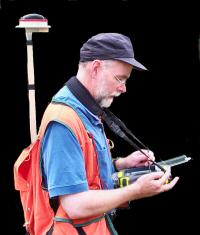 A pole-mounted, external antenna used with a recreational GPS and a PDA in a ruggedized case for data collection (click photo for details). | To get good GPS signals with a handheld unit, the receiver's antenna must be oriented correctly. Units like the Garmin eTrex and Geko with a patch antenna work best held horizontally so the face of the unit looks up at the sky. Others with a quad-helix type antenna (like the Garmin 72/76 series or the Magellan Meridian) work best with the top edge pointed skyward. Trying to maintain an ideal antenna orientation can be annoying if you are carrying a GPS, especially while hiking or doing other field work. An external antenna is a perfect solution if your unit accepts one. Following are a few options: | | 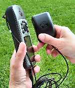 | -
Small, light antennas like a low-profile Garmin 27C (left, a thin black box small as half a deck of cards, costing about $70) can be attached to your hat or to the top of a pole on a backpack or vest. Such units draw very little power from a GPS unit but can boost signal strength. With an external antenna attached, you can put the GPS unit out of the way inside your coat or in a pocket (a convenient way to maintain battery performance in very cold weather). | |  | | | 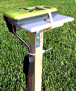 | -
Simply mount your handheld GPS in the proper orientation on a pole attached to a backpack or vest. (The lightweight, waterproof Geko 201 works well as an external antenna for field work.) Connect the GPS with a cable to a Palm or Pocket PC and use software on the PDA to view maps and record locations. Bluetooth GPS units that communicate with PDAs without the use of any cables are also available. | | | External Power Supply | |  Any GPS unit or other electronic device with a power supply cable that connects to a 12-volt cigarette lighter outlet can be operated with a portable battery in the field. 12-volt power supplies are relatively inexpensive ($30 to $80) but heavy (three to seven pounds). They are often sold in carrying cases, complete with AC and DC recharging systems. If you are running multiple tools (such as external antennas, data collectors and cellular phones), you might want a power supply with multiple ports. CycoActive also offers a light-weight C-cell battery pack for eTrex and Geko GPS units. Any GPS unit or other electronic device with a power supply cable that connects to a 12-volt cigarette lighter outlet can be operated with a portable battery in the field. 12-volt power supplies are relatively inexpensive ($30 to $80) but heavy (three to seven pounds). They are often sold in carrying cases, complete with AC and DC recharging systems. If you are running multiple tools (such as external antennas, data collectors and cellular phones), you might want a power supply with multiple ports. CycoActive also offers a light-weight C-cell battery pack for eTrex and Geko GPS units. | | Comments | -
Recreational grade units are a good companion alongside a clipboard, paper and pencil for field work. Write down waypoint numbers for manual data plots and review your GPS track as you proceed or later in the office. -
Transfer waypoints or tracks (based on property corners or boundary lines) from an aerial photo to the GPS unit to use as references when traversing a parcel of land. -
Recreational grade GPS units work well with a variety of field data recorders, including relatively inexpensive Pocket PC devices like the iPAQ or ruggedized units like the Juniper Allegro®. | | More Information | | | | | | | Does the new GPS technology mean that resource managers are likely to abandon their compasses and stop pacing to measure the distance they've covered? Maybe. Many will find that the most efficient way to move quickly across the countryside is still by sighting through a compass notch and counting steps. If you've done much fieldwork, though, you know that after making a few offsets to get around bramble patches, cliffs or sinkholes and swatting mosquitoes (losing your pace count), your precise location can get ...well, a little hazy. In those situations, a GPS location fix can help you get back or stay on course. For other resource managers, GPS combined with the use of handheld data recorders will revolutionize field inventory procedures. The new tools allow foresters, for example, to see real time maps of where they are in the woods. Sampling grids can be overlain on maps, with GPS guiding foresters to each sample plot location. The resulting data can be more accurate and processed in record time compared to traditional navigation and manual data entry. The grade of GPS unit you select depends on the type of field work or data collection involved. In many instances (including most forest inventory tasks), a recreational grade unit may be entirely adequate. If a forester were setting up a timber harvest, however, that's a different situation. When a couple dozen trees get cut across the neighbor's property line because of a mere 66-foot GPS error, the neighbor is likely to be hopping mad! Better use a resource/mapping grade GPS if you are relying on the instrument for boundary location or research where location and area calculations are critical.
| | Top / About | | |
