|
|
|
Forestry
GIS (fGIS)
is a
compact but robust
shapefile
editing program, digitizer and GIS data query tool for Windows®.
fGIS was designed for natural resource managers who are
not GIS specialists. Its easy-to-use and simple to install.
Many
power users also like fGIS because they can run it on laptops
or home computers without copyright issues, it produces
data compatible with commercial GIS programs, and fGIS is
free.
|
 |
|
|
| Notice!
As of November 7, 2005, Forestry GIS (fGIS) updates are no longer
available for public download. Although
Wisconsin DNR continues to improve fGIS, a change in the license
agreement for the TatukGIS Developer Kernel would require payment
of royalties to distribute newer versions of fGIS outside of DNR
programs. A list of updates to fGIS
since the September 24, 2005 build is available, which might explain
bugs you encounter in the older version. (You can continue to use
and freely share versions of fGIS released before November 7, 2005.)
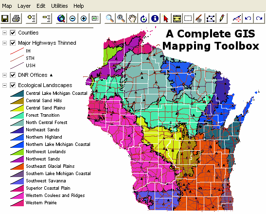
As shown in the fGIS
Quick Start Guide, the program arranges geographic themes
(layers) in a simple table of contents. The order of layers can
be changed by dragging them up or down. Layers can be made semi-transparent
if needed to view information underneath. Symbols, lines and fills
can be changed with flexible property menus. Users can add their
own point, line or area objects by tracing over aerial photos
or other maps. Length and area values in US or metric measures
are calculated automatically. Users can also import tabular and
GPS data.
You'll
find that fGIS is relatively simple to use:
-
Open
and view geo-referenced raster images including digital orthophotos
and topographic maps in MrSID®, ECW, BIL, ADF, JPG, TIFF,
GeoTIFF, BMP, IMG, JPEG2000, PNG and SDTS file formats.
-
Open
and view vector data in ESRI® shapefile (SHP) and e00 files,
AutoCAD DXF, MapInfo® MIF, Microstation® DGN, DLG-O, TIGER2000/line,
GML/XML, SDTS and TatukGIS SQL (ttkls) file formats. An advanced
R-Tree index system allows easy viewing of large (100+ MB)
data files.
-
Create
and edit point, line and area shapefile objects and their
associated data attribute tables. fGIS also edits and writes
MIF, DXF, DLG & GML vector layers.
-
Buffer
point, line or area objects at any designated radius or width.
-
Generate
Cruise Points. Select an area object and fill it with either
a random or ordered grid.
-
Design maps with pre-defined layer symbology (PDF
preview 28KB), or use advanced layer properties to define
your own.
-
Copy
and paste shapefile objects from one layer to another.
-
Designate the direction and distance of the next leg of a
line or polygon with the COGO-like Traverse Tool. Directions
can be entered in decimal degrees or degrees-minutes-seconds
(handy for plotting deeds or laying out a field data collection
route).
-
Split a polygon or line (including GPS tracks) into separate
units by drawing a line with the Split Shapes Tool.
-
Clip Shapefiles to the boundaries of a polygon layer.
-
Merge
multiple shapefiles into a new one.
-
Customize
map properties including line width and color, area fills,
label fonts and positions, image transparency, thematic rendering
of data and more.
-
Measure
areas and distances. fGIS
reports distances and areas in English units (feet, miles
and acres) and metric units.
Area and perimeter measurement
fields can be added to data tables and updated automatically.
-
Display
data at user-specified scales.
-
View
maps in 3D.
-
Map
live GPS positions from any connected GPS unit with NMEA output
(beta).
-
Extract
geo-referenced images of selected portions of a screen display.
-
Export
part of a vector layer and save it as a new file.
-
Manage
large data sets organized in dBase tables with the "Load
Library Layer" utility.
-
Join
dBase and Access tables to shapefile attribute tables.
-
Create
point shapefiles from comma delimited text files with x|y
coordinates.
-
Convert
Geographic WGS84 coordinate shapefiles to and from worldwide
UTM zones and Wisconsin Transverse Mercator. (Use the
MN
DNR Garmin Tool for transferring shapefile waypoint and
track data to and from GPS units.)
-
Print
the map with three flexible output options. The Simple Print
command will add a map title, subtitle, footer and the scale
to the page. The Send Map to Word command will send an image
of the view at a user specified resolution and scale to Microsoft®
Word. A third option through the Export Image tool will send
the map to a technical illustration/page layout module called
Diagram Designer. You can add headers, legends, annotations
and non-spatial symbols from template palettes in the Diagram
Designer module.
-
Save
WMF files for use in publishing programs.
-
Georeference scanned images with fGIS and other available
freeware.
-
More
specifications and instructions are here.

|
Sample
Projects
You
can experiment with the following projects to understand
the basic techniques used by fGIS. The zip archives
include a project file (with a "ttkgp" extension),
all the data layers and property settings.
-
State_Park.zip
(3 MB) - Property boundaries, roads, streams,
aerial photos, etc. for Devil's Lake State Park
in Wisconsin USA.
-
Arborvitae.zip
(2MB) - Part of the Northern Highland State
Forest in Wisconsin, USA.
-
Forest_types.zip
(1MB) - Pie chart layer properties for forest
cover types in Wisconsin (by
TatukGIS).
-
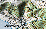
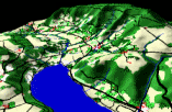
Tuerlen.zip
(4MB) - Türlen, Switzerland. The project
contributed by Stefan Lutz
(TOPTEC
Lutz) includes test data ©SwissTopo
and freeware symbol fonts for trees. To view a shaded
relief terrain, start the 3D Viewer from the Utilities
Menu and load Terrain-Model.tif as the DTM and one
of the BMP overlays (shown below).
|
|
|
Language Files
fGIS
includes a "language.ini" file (a simple text
file) that can be modified for languages other than
English.
The
alternative language files are located in the root fGIS
folder. They are named with an extension to indicate
which language they contain (e.g., the Deutsch [German]
file is named language.ini.de). To use one of these
alternate language files, begin by renaming the original
"language.ini" to "language.ini.bak"
with a file manager like Windows Explorer. Then rename
the language file you want fGIS to use as "language.ini".
(For French language users, a French
Help File is also available.)
If
you are interested in creating a translation, a helpful
software tool is called
"Translator" by Jernej Simoncic. It lists
the original language.ini file in the left pane, compared
to your translation in the right. Information about
how to create a compiled help file is available on request.
If
you create a unique "language.ini" file, please
send a copy.
Note
that the
Diagram Designer page layout module from Michael
Vinther also offers additional languages.
|
|
Where
Can I Get
Uniform Base Map Data for fGIS?
To
begin a mapping project in fGIS, you must type in a
project name and then import at least one geo-referenced
image or vector layer to establish a coordinate system.
fGIS requires that all data layers be in the same map
projection and datum or else they will not line up.
Wisconsin foresters can get image and vector data sets
from
Wisconsin DNR that are standardized in the Wisconsin
Transverse Mercator (WTM) 83/91 coordinate system.
For
others in the United States, TerraServerUSA is a ready
source of free aerial photographs and USGS topographic
maps in the UTM NAD83 coordinate system. There are a
number of programs that will download and save TerraServerUSA
images for use in fGIS (see freeware
USAPhotoMaps).
If you need to change the projection of images to a
different coordinate system, see DGWarp.
For
political boundaries, roads, streams, PLSS township
sections and other vector line layers, an easy approach
is to download shapefile data in Geographic (lat/lon)
format. The Shapefile Projection Utility in fGIS can
then convert the shapefiles from the Geographic to UTM
NAD83 format to match TerraServer images. If you need
free shapefile layers, check
ESRI®
or
MapShots® for starters. Another source, webGIS,
has hard-to-find Public Land Survey System DLG shapefile
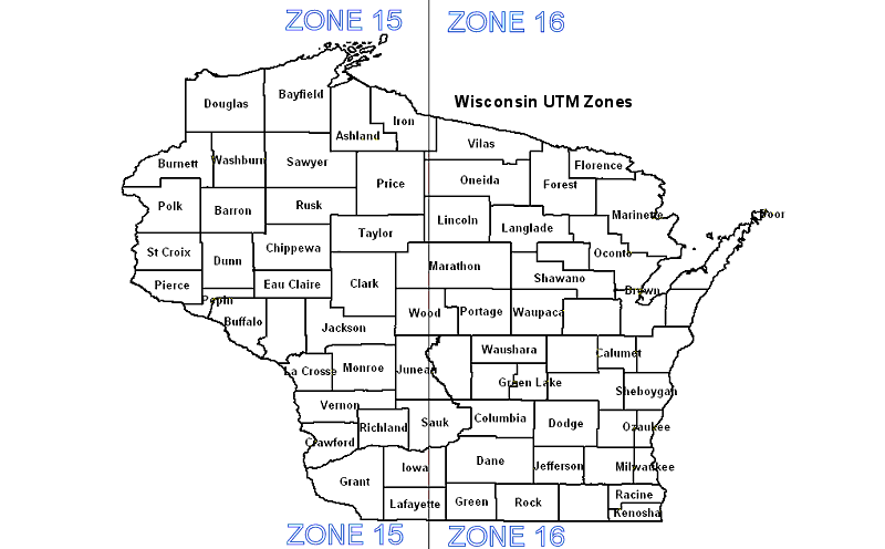
data derived from USGS quadrangle maps. (Wisconsin UTM
zones are here.
Check here
if you need the UTM zone number for a location elsewhere
in North America. See the USGS
site to learn more about the UTM projection.)
For
worldwide shapefile data, see
ESRI® or
Global GIS at the American
Geologic Institute.
Another
fine complement to fGIS is the freeware program
3DEM, which produces dazzling 3D color shaded relief
models. 3DEM can convert digital elevation data from
a number of formats to the UTM NAD83 coordinate system.
The program saves elevation image maps that can be easy
opened as layers in fGIS. fGIS can also blend TerraServer
aerial photos and 3DEM elevation maps in semi-transparent
overlays.
|
|
|
|

