|
In
the autumn of 2003, Paul
Bolstad, Jon Berkin, Kevin Horne, Department of
Forest Resources, University of Minnesota and William
H. Reading, North Central Research Station, U.S. Forest
Service conducted research comparing a variety of GIS-resource
grade and recreational grade GPS receivers. They looked
at a range of GPS receivers and configurations for collecting
data in the open and below northern forest canopies.
Bolstad
and his associates compared recreational receivers in
Wide Area Augmentation System (WAAS) mode, and expensive
receivers optimized for spatial data collection (GIS
receivers) in autonomous, WAAS, real-time differential,
and post-processed differential modes. Data were collected
over accurately surveyed open and sub-canopy locations.
Individual position fixes were logged for varying time
periods, and corrected using appropriate methods with
results statistically analyzed.
|
|
|
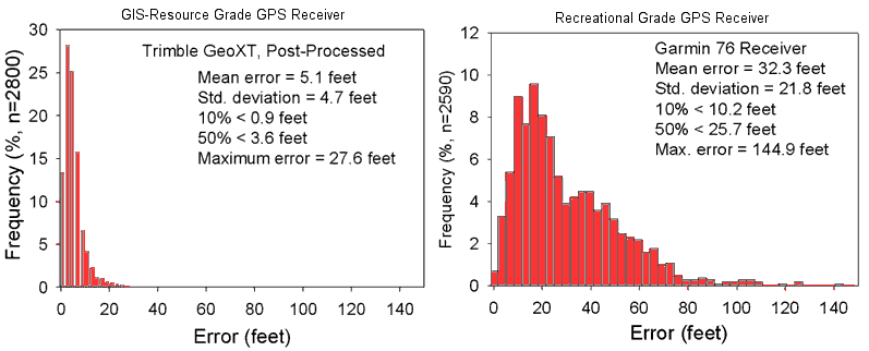
Examples
of the research results, comparing two of
five GPS receivers used in sub-canopy forest
conditions.
|
Their
findings indicate:
-
Significant differences in the mean positional error
due to receiver type under forest canopies, but
no statistically significant differences under open
locations.
-
Mean
errors averaged between 2.9 and 7.2 feet for points
in the open and between 8.2 and 23.4 feet below
a forest canopy depending upon the grade of receiver
(the recreational grade units showing the poorer
performance).
-
Mean
errors were significantly higher for the recreational
receivers than for GIS-resource grade receivers.
-
There
was no difference between differentially corrected
and uncorrected data when using the GIS receivers.
-
A
higher number of fixes increased accuracy for two
out of the eight receiver/configurations tested,
but did not affect accuracy for the six others tested.
-
Recreational receiver accuracies were much less
consistent, with higher frequencies of large errors.
-
Sub-canopy tests in northern Minnesota indicate
WAAS signals were only available between 8 (moving)
and 23 (stationary) percent of the time for the
recreational receivers, and between 22 (moving)
and 33 (stationary) percent of the time when using
GIS-resource grade receivers.
The
tests evaluated five different Course Acquisition (C/A)
code receivers including two inexpensive ($200) recreational
grade GPS receivers (Garmin 76 and Deluo) and three
expensive GIS grade systems (Trimble Geoexporer 3,
Trimble GeoXT and a Leica L5). The GIS grade units
(costing 10 to 25 times the price of recreational grade
receivers) are specifically designed for accurate data
collection under a range of conditions.
Replicate tests were conducted for each receiver. A
test consisted of standing over a known point with the
receiver, beginning acquisition, obtaining position
fixes until an established number was collected, noting
the average position location, and if appropriate, saving
the collected data to a file for further processing.
Receivers were held between chest and head height, approximately
four to six feet above the ground, without an external
antenna.
The
researchers collected a number of position fixes and
averaged these to estimate coordinate location at each
point. They collected 1, 10, 50, 100, 200, and 300 fixes
each time a point was visited. A total of seven replicates
were collected for each known point.
Accuracy differences among the more accurate receivers
(Trimble, Leica) and poorer subcanopy receivers (Deluo,
Garmin) are attributed to differences in their ability
to reject multi-path measurements, or in the data reduction
and position calculation algorithms built into each
receiver. Some manufacturers invest heavily in research
and development and have patented, proprietary signal
processing methods. These both increase the accuracy
of measurement and identify degraded or multli-path
signals. Multi-path signals are received when transmissions
are reflected from trees, soil, or other solid objects
between the GPS satellite and the field receiver.
The
researchers made a couple of ancillary observations
while conducting their measurements:
-
Raising
the antenna can increase signal acquisition and
reduce data collection times. Pauses during field
data collection due to loss of lock on satellites
lasted from a few seconds to several minutes. Raising
the receiver to six to eight feet above the ground
substantially shortened the duration of the pause
for all receivers. Although not quantified, it was
an improvement noted by all observers. Our experiences
in this and other studies suggests a telescoping
pole and external antenna are warranted when collecting
GPS positions sub-canopy, and may provide substantial
gains in efficiency, and perhaps accuracy.
-
Although
the researchers did not test the importance of antenna
orientation, this may also have an impact on data
collection accuracy. Both quadrifilar (Garmin 76)
and patch antennas (all others) were used. The patch
type typically works best when horizontal, and the
quadrifilar when oriented vertically. In past work
they noted an apparent decrease in accuracy with
improper orientation, but did not test its affects
here. While the researchers were careful to maintain
proper antenna orientation in the study, past experience
showed an apparent decrease in accuracy with improper
orientation.
The
investigators would like to better quantify impacts
of both antenna height and orientation across the range
of available equipment, perhaps as a future project.
Although there are differences in accuracy between recreational
and GIS grade GPS receivers, the lower accuracy of the
recreational grade units may be acceptable depending
upon the work being done.
If
a majority of the work is in open conditions, then the
relatively high accuracies and lack of difference among
types suggest the recreational grade receivers are preferred.
Errors of three to seven feet are much better than those
obtained using pacing, chaining, or photo delineation
for decades, and are generally more than adequate for
most forest management activities. (Selection of receiver
type and methods may also be based on other criteria,
such as cost, size, ruggedness, associated software,
battery life, expandability, or software capabilities.)
Selecting the appropriate receiver and methods might
be more complicated when a major portion of GPS data
collection will be below forest canopies. If single-fix
errors are acceptable that average above 20 feet and
are frequently above 60 feet when working below a forest
canopy, then the less expensive recreation grade receivers
may be the best choice. These errors are smaller than
those obtained using previously acceptable paper and
pencil methods, prior to the advent of GPS, and may
meet the accuracy requirements of many resource management
activities. Basic receivers such as the Garmin 76 or
Deluo may also be appropriate when time allows multiple
fixes at a point, e.g., when measurements at a cruise
point lasts several minutes, or when cost considerations
are primary.
Recreational grade receivers may also be used when digitizing
linear features or area boundaries where common errors
on the order of 30 to 60 feet are acceptable. This may
be the case when the area to be measured is large relative
to the perimeter, e.g., tens to hundreds of acres in
a shape that is approximately round or square.
However, when the line, or area features need to be
located to within 10 feet or less, e.g., when the areas
to be measured are small, or when the areas are long
and thin, then the higher end, more consistently accurate
GIS receivers may be preferred.
-------------------
March 20, 2004
The
preceding information is used with permission of
Paul
Bolstad, Jon Berkin, Kevin Horne, Department of
Forest Resources, University of Minnesota and William
H. Reading, North Central Research Station, U.S. Forest
Service. A
complete report of the GPS comparison research is expected
to be published in 2004. Watch for it!
|
