|
|
|

|
A
couple years ago I wanted something different as a gift for my
wife, Karen. She enjoys exploring outdoors and keeps a journal
with the locations of wild flowers she finds on her walks. I thought
she might like a Global Positioning System (GPS) unit. With a
GPS you can record your location to within a few feet. As it turns
out, the Garmin GPS unit is one of her favorite gifts. Karen memorized
the instruction book and within a day was exploring the backwoods
of Devils Lake State Park in southern Wisconsin.
She especially liked the GPS
unit because there are many places she wanted to go where there
are no trails. Now when she starts a walk, she can click the unit
and record where the car is parked. She can also enter coordinates
for points she wants to travel to. As she hikes in the woods,
the GPS unit keeps track of where she is in relation to any of
the points shes interested in. The unit will tell her if:
-
shes going in the right
direction
-
how far away the point
of interest is
-
how fast she is moving
toward it.
All that information is displayed
on a screen that fits in the palm of her hand.
|
|
|
|
 So
how does GPS work? The US Air Force maintains a "constellation"
of at least twenty-four GPS satellites that orbit the earth. The
satellites are like the stars that people have navigated with
for ages. The only difference is that the GPS "stars"
send out radio transmissions that an antenna in your GPS unit
picks up. If the GPS unit can get a signal from four satellites,
it will calculate where it is by using an internal clock and simple
geometry. Atmospheric interference, mathematical rounding, small
errors in the satellites' atomic clocks and other factors introduce
faults in the location estimate. An error of one billionth of
a second in the clock translates into about a one-foot error on
the ground. The more satellites a GPS unit gets a signal from,
the smaller that error is likely to be. A unit with a differential
correction feature called "WAAS" can be accurate to
within about 10-16 feet on a fairly consistent basis. So
how does GPS work? The US Air Force maintains a "constellation"
of at least twenty-four GPS satellites that orbit the earth. The
satellites are like the stars that people have navigated with
for ages. The only difference is that the GPS "stars"
send out radio transmissions that an antenna in your GPS unit
picks up. If the GPS unit can get a signal from four satellites,
it will calculate where it is by using an internal clock and simple
geometry. Atmospheric interference, mathematical rounding, small
errors in the satellites' atomic clocks and other factors introduce
faults in the location estimate. An error of one billionth of
a second in the clock translates into about a one-foot error on
the ground. The more satellites a GPS unit gets a signal from,
the smaller that error is likely to be. A unit with a differential
correction feature called "WAAS" can be accurate to
within about 10-16 feet on a fairly consistent basis.
|
|
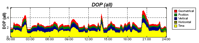
To
check her GPS units accuracy, Karen switches screens (by clicking
a button), and it shows her how many satellites it can "see"
and what the estimated precision error is at that moment. The
location of each satellite in relation to the others and their
geometry relative to the GPS unit affects the Dilution of Precision
(DOP). DOP values change through the day as the satellites
move in and out of view as shown in the above sample chart for
a specific day/location. The graph was produced by Trimble's
GPS Planning Software. The lower the DOP value, the better
your GPS location calculation is likely to be. Dense tree
foliage, obstructions like hills and buildings or holding the
GPS unit too close to your body can also block signals and reduce
accuracy.
Although
Karen's GPS seldom shows an estimated error greater than 60 feet,
she is realistic about her units accuracy. She wouldnt pretend
to be a surveyor with it. If she were looking for a section corner,
den tree, deer stand, patch of flowers or our parked car, though,
she can come relatively close.
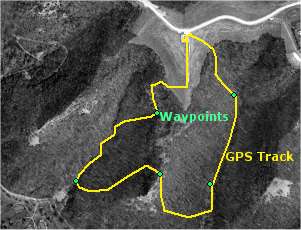
 The
main difference between recreational grade GPS units is whether
or not they display a base map. The less expensive units like
Karen's basic eTrex costing about $100 have no built-in maps but
are still very handy. They keep track of where you go with a dotted
line on the screen. The screen will also show waypoints, which
are ground locations that you click on as you travel or which
you enter in advance as latitude/longitude coordinates. More advanced
units costing $200 to $500 have built-in maps showing roads and
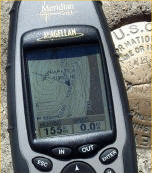
streets. Some units (like my Magellan on the left) display topographic
elevation lines that are downloaded from companion CDs such as
Magellan's MapSend or Garmin's MapSource products. The
main difference between recreational grade GPS units is whether
or not they display a base map. The less expensive units like
Karen's basic eTrex costing about $100 have no built-in maps but
are still very handy. They keep track of where you go with a dotted
line on the screen. The screen will also show waypoints, which
are ground locations that you click on as you travel or which
you enter in advance as latitude/longitude coordinates. More advanced
units costing $200 to $500 have built-in maps showing roads and
streets. Some units (like my Magellan on the left) display topographic
elevation lines that are downloaded from companion CDs such as
Magellan's MapSend or Garmin's MapSource products.
If you are looking for a GPS
unit, get one with the Wide Area Augmentation System (WAAS) feature.
WAAS GPS units track a couple extra geostationary satellites that
send out correction signals, enabling accuracy to around 10 to
16 feet under ideal conditions. Garmin,
Magellan
and Lowrance
are some of the more popular GPS brands featuring WAAS.
 Recently,
I started using a Garmin GPS76S for work (purchased for about
$360 from Amazon). The unit has built-in maps and a larger display
like the Magellan. It also includes an electronic compass (which
works with the unit held horizontally) and a built-in barometric
altimeter to improve the accuracy of elevation readings. Recently,
I started using a Garmin GPS76S for work (purchased for about
$360 from Amazon). The unit has built-in maps and a larger display
like the Magellan. It also includes an electronic compass (which
works with the unit held horizontally) and a built-in barometric
altimeter to improve the accuracy of elevation readings.
The GPS76S is a great unit,
but the extras do shorten battery life. Karen's little Garmin
eTrex is good for a couple days of hiking, rated at about 20 hours
on two rechargeable AA batteries. My Magellan Meridian Gold unit
is rated at 14 hours and hasn't had any trouble lasting an eight-hour
field day. (The only complaint I have about the Magellan is that
the power button sticks out too far, frequently causing the unit
to be unintentionally turned off.) The Garmin GPS76S is rated
at 10 hours with 2 AA batteries, however it might not last three
hours on some cold winter days. All the bells and whistles cause
a power drain, meaning you better have more batteries in your
pocket.
If you don't really need the
extra features like an electronic compass and altimeter, the longer
battery life found in simpler units could more than outweigh the
prestige of having a top-of-the-line unit. You would also be wise
to carry a conventional magnetic compass and not rely entirely
on your GPS unit in field situations.
|
|
If you want to get the most out of a GPS unit, use it with
a computer-mapping program. Karen and I use USA
PhotoMaps and OziExplorer for
2D maps or 3DEM for 3D views.
They are available for free download from the Internet. Delorme's
Topo USA, which costs about $100, is another excellent program
to use with your GPS Unit. The programs communicate with the GPS
unit via a cable that connects it to the computer. They download
the tracks and waypoints from the GPS unit and draw them on a
map.
 |
 |
|
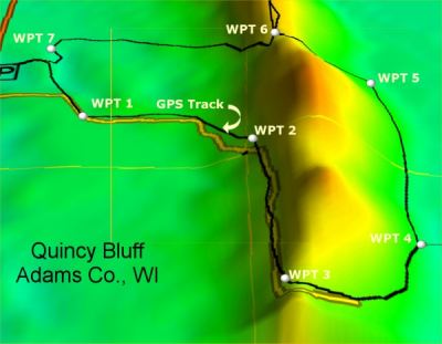
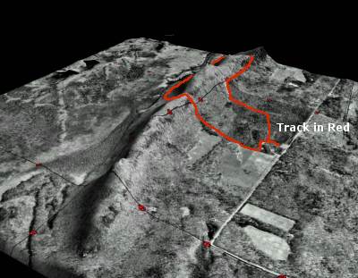
The
images above show the track of a hike at Wisconsin's Quincy
Bluff, a 200-foot high sandstone ridge surrounded by flat
lowlands. To help the ridge stand out, a 250% vertical exaggeration
was applied in 3DEM.
If you are debating about getting a GPS unit, dont hesitate.
Considering the low price and reasonable accuracy, anyone
who wants the freedom and security of knowing where they
are shouldnt be without one.
You
might wonder, "Which is the right GPS unit for the
job?" There are three general grades of GPS units:
recreational grade, mapping or resource grade and survey
grade. See the GPS Comparisons
to help choose the right tool for you.
|
|
|
Top
/ About
|
|
|
