|
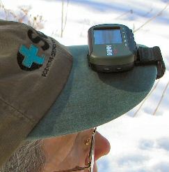
The
Garmin Foretrex 201 fits comfortably of the bill of a hat.
|
Positioning the GPS receiver as shown improves satellite
reception by moving it out of your shadow and giving the
unit a view of the sky.
|
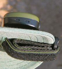
Make
a slit in the hat bill, and then loop the Velcro®
wrist strap as shown to secure it to the cap.
|
|
The
Garmin Foretrex 201 has become my favorite GPS receiver
for forest reconnaissance and general field navigation.
As shown in the photos, the advantage is its small size
and ability to be attached to a baseball cap. The Foretrex
was designed to be worn on a wrist or upper arm, where it
works reasonably well most of the time (but signal strength
will drop if the receiver isn't oriented skyward, especially
in the woods). Put it on the bill of your hat, however,
and the unit will maintain solid 3D satellite reception
even among trees. The Foretrex 201 is so light in weight
that you won't even notice it. I also like my hands and
arms unencumbered.
Be
sure to choose a GPS receiver that's right for the task
you are doing. If you need to reference your position
on basemaps
frequently,
a hat-mounted Foretrex isn't for you. Likewise, if you collect
a lot field data with GPS coordinates, you'll want a hand-held
mapping grade unit instead. People who do not reference
the GPS screen very often will, however, find the Foretrex
ideal. I prefer a good Silva® compass for quick navigation,
but the GPS unit is indispensable for checking my position
relative to cataloged positions or property boundaries.
The GPS is also essential for recording plot waypoints,
which you can enter without looking at the unit by listening
to audible beeps. Just note the waypoint number or time
on your field sheet or PDA and then correlate the cruise
data back at the office.
The
Foretrex 201 comes with a serial data cable for transferring
information to and from your PC. To use it, snap on
a separate accessory cradle to the back of the Foretrex.
The unit is otherwise flat and smooth and no bigger than
a couple packs of chewing gum. An AC recharging cable also
plugs into the same snap-on jack.
The
rechargeable lithium-ion battery in the Foretrex 201 works
well for me, lasting an entire field day. You do need to
remember to recharge the unit before going out again. That
takes two to three hours. Some people might prefer the Foretrex
101, which uses two AAA batteries (you can carry extras),
but is otherwise identical in function. The added thickness
of the 101 is barely noticeable. The 101 model does not
require the snap-on accessory cradle (which might be easy
to misplace) used by the 201. You must, however, purchase
the serial data cable separately if you intend to use the
101 with your PC. That and the price of batteries will make
the net cost of the two units nearly the same. I've read
in New Scientist that current lithium-ion batteries may
be limited to about 200 recharges, and so that could add
repair costs to the 201 after a few years.
As
for the track and waypoint data saved by the Foretrex, it's
just as good as the bigger Garmin GPSMAP 76, eTrex and Geko
models that I also use. The Foretrex has WAAS differential
correction that reduces the positional error to less than
a few meters when you have a clear view of the southern
horizon, available only out in the open
in my northern latitude.
Considering the small size and overall freedom and convenience
in the field, the Foretrex will be the first unit that I
reach for. Its relatively low price is also attractive.
|