|
|
|
Getting Started with
SurGe Gridding and Mapping Software
|
|
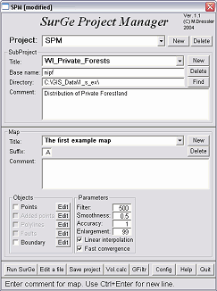 |
SurGe
opens with a Project Manager to locate data files and
to set the basic parameters of your mapping project.
This enhanced interface is new to SurGe version five.
It's a pleasure to use with well-organized features.
You'll
need to load a basic data file to begin. Input data
must be in a tab (or space) delimited text file organized
in four columns with the x-y coordinates of each data
point, the data value (z) and a label. A technique
for creating data files follows, below.
SurGe
employs an inventive file naming convention. Data files
must end with a three letter extension starting with
"dt" (e.g., "project_name.dt_").
The third letter (the "suffix") can be the
characters a-z or 0-9. The suffix can be used to distinguish
different versions of your data set. Suffix "a"
might be the original data, where "b" might
be a percentage of the original or some other factor
you want to compare to the original.
Type
in a data file name prefix or use the "Find"
button to browse folders. (If this is the first time
you've used SurGe, the program comes with a folder that
includes a couple of examples that you can experiment
with. Additional sample data used
for the maps on this page are available as a zip file,
below.)
After
locating the data files you want to map, click the "Run
SurGe" button.
|
|
|
SurGe
Example
|
|
|
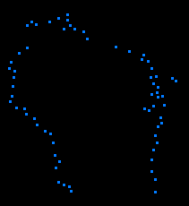
I
prefer to begin a project by making a map boundary. Without a
map boundary, the color gradients will flow to the edge of the
screen.
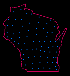
In
this case, I've opened a data file that has points around the
edge of the State of Wisconsin outline. To create a boundary file,
press Enter on the keyboard (which causes SurGe to enter a digitizing
mode) then type Ctrl-H (which starts a boundary). Left click each
boundary point in sequence (like a dot-to-dot coloring book) to
create a boundary polygon with a red line. Type "U"
to close the polygon, and then choose Object/Save. Boundary files
may contain up to 777 points.
A
boundary is saved as "project_name.HR". You can re-use
the boundary with other projects by copying the file and renaming
the prefix to match your actual project name. SurGe will automatically
load the boundary file (n.HR) if it is present with a data file
(n.dt_) that has the same prefix name (n).
See
the procedure below for creating the
points for a data file.
|
|
|
The
next step is to open the project's data points. If the project
has a pre-existing boundary file (made as explained above), it
will also be loaded.
SurGe
needs to create a grid file for the data before it can display
color contours or other maps. Choose "Interpolation/Calculate
Grid" from the menu bar. A DOS window will open that
runs a subprogram to calculate the grid. You are given the opportunity
to enter a number of parameters. The basic one to change from
the default on the first run is the grid size in the X direction.
That determines the size of the map that will be produced. You
might want to start with X set at about 300 (circled in red).
You can increase the value later if you want a larger map.
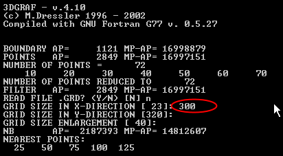
The program will set a proportional height (Y=320, above), which
you should accept by pressing Enter. Press Enter to accept each
of the other defaults on the first run. When the subroutine is
finished, press Enter to return to the main SurGe screen.
|
|
|
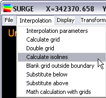
You
are almost ready to make data maps.
First,
be sure you have completed the step above to calculate the grid.
If you want to make an isoline map, you will also need to calculate
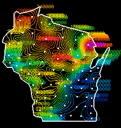
isolines as shown in the menu selection on the left.
|
|
Next,
tell Surge to blank out the area outside of the map boundary as
shown below:
|
|
|
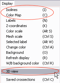
Now
make your maps. From the menu bar, choose "Display"
and pick either Isolines (right), Color Map (above), or 3D View
(below). Use the keyboard shortcuts if you wish. You can choose
whether or not to display point
labels and values, the color scale and other options.
|
 |
|
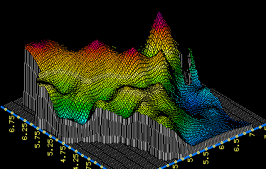
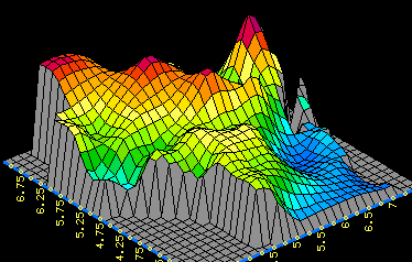
3D
View is a separate mode with additional menu choices that customize
and move or rotate the display. If you make a 3D View, SurGe will
ask how many "steps" to read the grid file. The step
value will set the cell size. A step of 3 is shown on the left,
with a step of 10 on the right.
SurGe
offers many options for adjusting the interpolation parameters,
defining fault lines, making cross sections and other features.
See the user
manual for details.
|
|
Making
Data Files
The
challenge in using SurGe is understanding how to create the text
files used either for boundary or data points. My technique involves
three freeware programs and a spreadsheet program like Microsoft®
Excel:
-
Use
fGIS to digitize either boundary points
or data point locations into a shapefile. Load a raster image
or vector data into fGIS as a reference basemap. Create a
new point shapefile layer in fGIS to hold either boundary
points or data points that you want to map in SurGe.
Digitize the points in fGIS and save the shapefile. If you
don't know how to operate fGIS, see fGIS
Help. (Data points can also come from other sources, such
as GPS data.)
-
Next,
you need to convert the shapefile points from step 1 into
a tab-delimited data file for use in SurGe.
-
Open the shapefile with the freeware
Massachusetts DXF Author and convert it to a DXF file.
-
Open the DXF file in the freeware program
DXF2XYZ. DXF2XYZ can convert the DXF file to a comma
delimited text file with three columns.
-
Start Excel and import the XYZ text file. If you are making
a boundary file, the z values can be set to zero. A fourth
column with a dummy value must also be added if you are
making a file for boundary points. If you are making a
data file, you can enter the actual z values (third column)
and labels (fourth column) at this time. Save the file
as a tab-delimited text file.
-
Use
Windows Explorer to rename the tab-delimited text file
to have a ".dt_" extension as explained above.
That's
all there is to it. If you wish, you can set or modify the values
of data points within SurGe. There are also other methods to create
data text files to use in SurGe (it's easier, for example, if
you have the registered version of Global Mapper), but the above
technique works at no cost.
If you'd like to experiment with my data files
used in the example above, download and unzip the following file:
Wisconsin_ex.zip (268 KB)
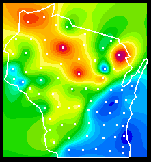
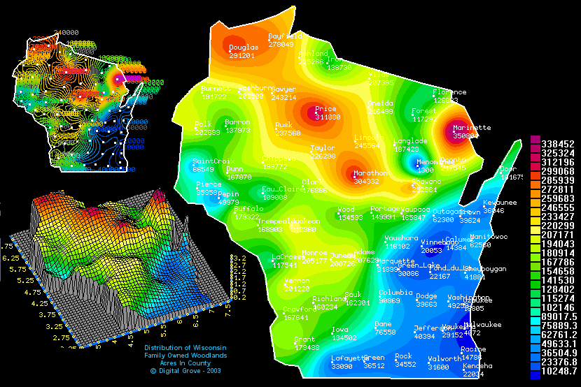
The
data in the zip archive shows the acreage of family-owned (non-industrial,
private) forest land in each Wisconsin county. The zip archive
includes data (dta), boundary (HR), grid (GRa) and isoline (vra)
files, so you can immediately go to the display options.
You
can substitute other Wisconsin data for the z values in the "dta"
file and re-use the boundary file (if you rename the file prefix
to match the data file). Here, for example, is a color contour
map of the acreage planted to corn for grain in 2001:
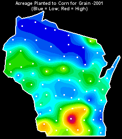
Additional agricultural statistics can be found at:
http://www.nass.usda.gov:81/ipedb/
Download
a copy of SurGe here
(GeoCities) or here
(Czech site).
|
|
Return
to the ForestPal Toolbox
ForestPal©
|
|
|