|
Download
the TatukGIS Free
Viewer (8 MB)
Download the Viewer
Documentation and Tutorial (7 MB PDF)
Download the State
Park Example Project (3 MB ZIP)
TatukGIS Viewer features, many
of which are found in no other free viewer:
- Export and save georeferenced
image files of all visible layers, with a choice of full or
visible extent. Choose the resolution of the export from best
(matching the resolution of loaded images), document (300 dpi),
web (96 dpi) or custom settings.
- Save project files, including
pointers to all loaded files. Layer property settings may also
be saved for painting to other layers that you wish to have
similar display characteristics.
- Open/read data in the following
file formats:
- Raster image: TIFF/GeoTIFF,
ECW, MrSID, JPEG2000, JPEG, IMG, BMP, BIL/SPOT, PNG, CADRG,
TatukGIS PixelStore
- Vector: SHP, E00, MIF/MID,
TAB, DXF, DGN, TIGER, GML, VPF, GDF, DLG, SDTS, Geomedia®
SQL Server & Access Warehouses, SQL layers with OPENGIS®
features implementation
- DTM formats: ASCII GRID,
FLOAT GRID, BT, DTED, and ADF
- Georeferenced Images: GeoTIFF,
World File, and TAB based
- All formats supported natively,
with no importing of data to any internal format
- Open data in many different
formats in the same project, with no need for format conversion
- Open most ESRI ArcView®, ArcExplorer®,
or MapInfo Professional® projects as well as TatukGIS project
files
- Zoom in/out, pan
- User defined scale for viewing/printing
- Very fast with huge data sets
(handles SHP files up to 2 gigabytes!)
- R-tree spatial indexing
- Layer control to add, remove,
and reorder layers in a project
- Alter the appearance (colors,
styles, fills, outlines, symbols, transparency, etc.) of vector
layers
- Use GCM, WMF, and TrueType symbols
to represent points, lines, polygon fills and perimeters
- Manipulate pixel layers, including
transparency, histogram, brightness, color enhancing, etc.
- Render custom thematic maps
based on vector attribute information, including colored-gradient
value themes
- Present data as bar and pie
charts
- Spatial queries (by point, line,
circle, rectangle, polygon, and custom clipboard layer)
- Attribute queries with SQL Builder
- Measurement of distances, areas,
and perimeters
- Custom render label appearances
and positions, multi-field labeling
- URL Hotlink for automatic linking
objects to any document referenced with a valid URL (web page,
file, even mailto)
- Map hints to automatically display
information about any feature under the cursor
- Data table to present attribute
data in table form
- Print and print preview, print
to PDF file
- Copy visible extent of all layers
to Windows clipboard using the EMF meta format
- Export any map view to image
files: TIFF/GeoTIFF (w/ LZW), JPEG, PNG, PixelStore
- Mosaic multiple already georeferenced
images into a single exported image file
- Very small footprint program
is only approx. 2.5 Mb (excluding the 5 Mb of tutorials/help
files with images)
- The Viewer includes the "Internet
Server Wizard" to easily set up a simple ASP.NET project
for web publishing with the TatukGIS Internet Server. Click
here to review on-line a sample project that was prepared
with the free Viewer and web published with the IS LITE.
- Program user interface is customizable
to the following languages: English, German, Spanish, Portuguese,
French, Italian, Greek, Swedish, Polish, Czech, Russian, Ukrainian,
and Japanese.
Besides just opening and viewing
files, the Viewer supports an extensive list of features including
layer control, thematic mapping, spatial and attribute querying,
custom labeling, on map measurements, PDF export and much more.
The user interface is available in 13 languages.
Because the Viewer is compiled
from the TatukGIS Developer Kernel toolkit, it provides an easy
way to evaluate the TatukGIS technology and support for various
data formats and common GIS functionality. The free Viewer can
be used to generate TatukGIS project files that are compatible
with any TatukGIS product or custom application created from the
TatukGIS DK toolkit. The Viewer can generate simple ASP.NET projects
for web publishing with the TatukGIS Internet Server.
The TatukGIS Editor product
extends the free Viewer by adding an extensive set of GIS editing
features.
Screen
Shots from Viewer Tutorials:
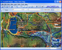
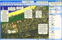 Click to enlarge; The
most important menu controls in the main Viewer window. Multiple
vector layers with a raster image background.
Click to enlarge; The
most important menu controls in the main Viewer window. Multiple
vector layers with a raster image background.
|
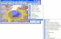
 Click to enlarge; More
menu controls. Use of symbols for points.
Click to enlarge; More
menu controls. Use of symbols for points.
|
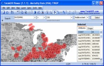
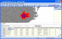 Click to enlarge; Spatial
selection and presentation of attribute information as a table.
Click to enlarge; Spatial
selection and presentation of attribute information as a table.
|
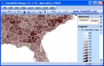 Click to enlarge; A
colored-gradient value theme presenting the range of values
of a selected attribute.
Click to enlarge; A
colored-gradient value theme presenting the range of values
of a selected attribute.
|
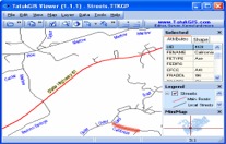 Click to enlarge; Rendering
of label styles and labels positions (to follow the line)
and street colors and widths based on the street type attribute.
Click to enlarge; Rendering
of label styles and labels positions (to follow the line)
and street colors and widths based on the street type attribute.
|
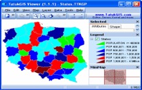 Click to enlarge; Polygon
areas rendered to reflect value ranges of a selected attribute.
Click to enlarge; Polygon
areas rendered to reflect value ranges of a selected attribute.
|
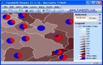 Click
to enlarge; Polygon colors and pie charts rendered to reflect
different attributes.
Click
to enlarge; Polygon colors and pie charts rendered to reflect
different attributes.
|
 Click to enlarge; Search tool used to query for a value
range of the selected attribute.
Click to enlarge; Search tool used to query for a value
range of the selected attribute.
|
 Click to enlarge; Operation
to select all polygon areas that are intersected by the circle.
Click to enlarge; Operation
to select all polygon areas that are intersected by the circle.
|
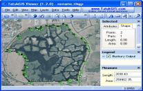 Click to enlarge; Use of the measurement
tool to measure the area and perimeter of a land feature.
Click to enlarge; Use of the measurement
tool to measure the area and perimeter of a land feature.
|
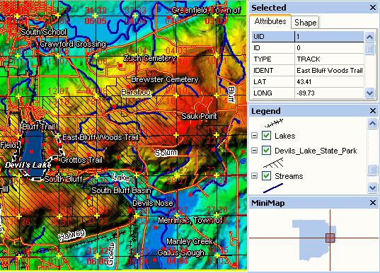
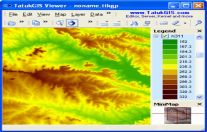 Click
to enlarge; The color rendering of Digital Terrain Model data. Click
to enlarge; The color rendering of Digital Terrain Model data.
|
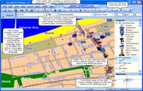
 Click to enlarge;
Variety of
label types, area fills and image transparency.
Click to enlarge;
Variety of
label types, area fills and image transparency.
|

For those who wonder
what "Tatuk" means (as in TatukGIS), it is a lake in
British Columbia, Canada.
Return
to Toolbox
|
